


PRECINCT GRAND PRAIRIE C, Marion County, Ohio
About
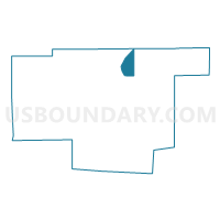
Outline

Summary
| Unique Area Identifier | 649808 |
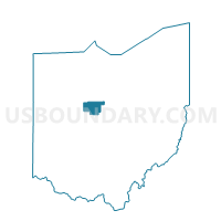
| Name | PRECINCT GRAND PRAIRIE C |
| County | Marion County |
| State | Ohio |
| Area (square miles) | 5.26 |
| Land Area (square miles) | 5.26 |
| Water Area (square miles) | 0.00 |
| % of Land Area | 100.00 |
| % of Water Area | 0.00 |
| Latitude of the Internal Point | 40.66788190 |
| Longtitude of the Internal Point | -83.08789730 |
Maps

Graphs
Select a template below for downloading or customizing gragh for PRECINCT GRAND PRAIRIE C, Marion County, Ohio


Neighbors
Neighoring Voting District (by Name) Neighboring Voting District on the Map
- PRECINCT CLARIDON TWP B, Marion County, OH
- PRECINCT GRAND PRAIRIE B, Marion County, OH
- PRECINCT MARION TWP H, Marion County, OH
- PRECINCT MARION TWP I, Marion County, OH
- PRECINCT SCOTT TWP, Marion County, OH
Top 10 Neighboring County Subdivision (by Population) Neighboring County Subdivision on the Map
- Marion township, Marion County, OH (44,749)
- Claridon township, Marion County, OH (2,742)
- Grand Prairie township, Marion County, OH (1,590)
- Scott township, Marion County, OH (498)